Türkiye is locked in a fierce battle against rapidly spreading wildfires that have engulfed vast forests in the western province of Izmir and the southern province of Hatay. Firefighters are scrambling day and night, deploying every available resource – from firefighting planes and helicopters to thousands of ground personnel and cutting-edge drone technology – in a race against time to protect lives, homes, and nature from the relentless blaze.
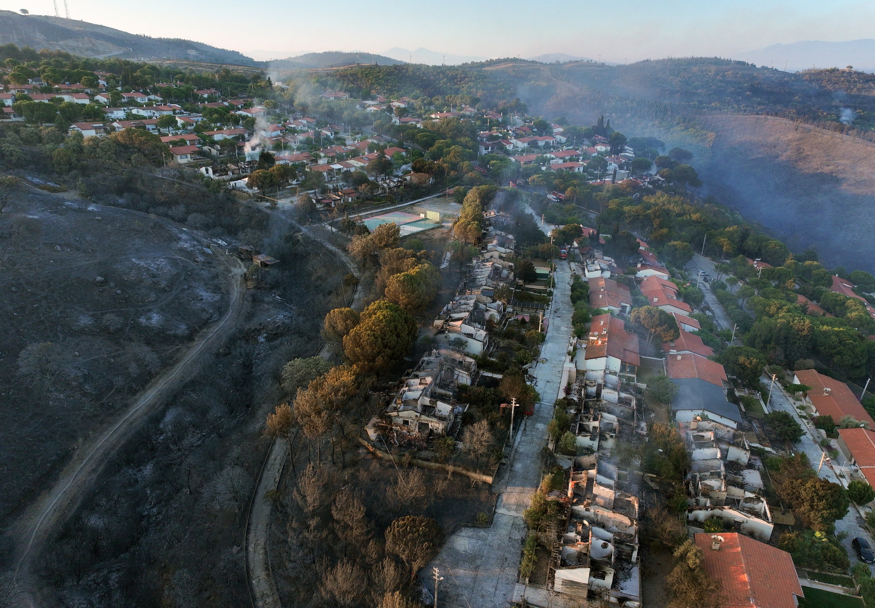
In Izmir, fires that broke out on June 29 in the districts of Seferihisar and Menderes entered their third day Monday. Ground crews worked through the night to contain the blazes in the Kuyucak neighborhood of Menderes and the Doğanbey neighborhood of Seferihisar. Aerial firefighting resumed at daybreak, with four planes, 10 helicopters, and numerous ground teams deployed to douse the flames. Turkish Armed Forces helicopters also joined the firefighting efforts.
The fires, fueled by strong winds, have spread over wide areas, prompting precautionary evacuations of multiple settlements in the region.
On Tuesday, the Presidency’s Directorate of Communications issued a statement on social media highlighting the country’s full mobilization to combat the fires. "Our land and air units are operating with maximum effort, and reinforcements in teams and equipment continue without interruption in high-risk areas," the statement said. It added that all coordination is meticulously managed by the General Directorate of Forestry under the Ministry of Agriculture and Forestry.
Türkiye’s firefighting air capacity has increased significantly since 2002, with 27 aircraft and 105 helicopters now deployed – up from 73 tons of water dropped annually in 2002 to 438 tons in 2025. Artificial intelligence systems have reduced fire detection times to just two minutes. Türkiye is a leader in drone usage for firefighting, with 14 unmanned aerial vehicles (UAVs) currently active in fire surveillance.
The firefighting workforce includes 8,500 new personnel this year, joining a total of 25,000 forestry workers and 131,000 volunteers. Ground equipment has also been expanded, with the number of fire trucks and water tankers rising from 637 in 2002 to 1,786 in 2025, supported by nearly 3,600 first-response vehicles and over 800 heavy machinery units. The country now has nearly 4,800 fire ponds and reservoirs to aid firefighting efforts.
In Hatay, a forest fire that began Sunday in the Antakya district’s Karaali neighborhood spread quickly to nearby Oğlakören and Üçgedik neighborhoods due to high winds. Fire crews continued ground operations through the night, with helicopters joining at dawn.
Hatay Governor Mustafa Masatlı visited the active fire zone in Alahan neighborhood Monday morning to oversee efforts. Sudden wind gusts caused panic among residents, some of whom took to their rooftops to spray water with hoses in an effort to protect their homes. Police and gendarmerie units deployed riot control vehicles to assist firefighting teams.
Three neighborhoods have been evacuated as a precaution. The cause of the fire is still under investigation.
In the southwestern province of Muğla, gendarmerie and commando teams have intensified patrols in forested areas amid heightened fire risk due to rising temperatures and strong winds. Authorities are raising public awareness about fire prevention, warning against lighting open fires or fireworks and cautioning beekeepers about the risks of smoke from hive treatments.
A force of 440 personnel is conducting controls to prevent field burning and unauthorized access to sensitive forest zones. Drone and UAV technologies are also used to monitor for signs of fire. Patrol teams, accompanied by specially trained police dogs, are questioning visitors to forest areas to enforce restrictions.
The General Directorate of Forestry employs cutting-edge technology in its firefighting campaign. Unmanned aerial vehicles equipped with domestically produced Aselsan “ASELFLIR-500” thermal cameras can detect fires from distances up to 215 kilometers (133.59 miles), scanning some 3.5 million hectares in real time.
These high-resolution infrared cameras, newly introduced this year, allow rapid identification of heat signatures even in challenging conditions, supporting quicker intervention. The cameras also feature laser targeting and precise tracking capabilities, usable across various air platforms, including planes and helicopters.